| |
|
|
Geophysics
Archaeological geophysics, known to television viewers as geofizz, gives us a group of techniques that can be
used to detect buried archaeological remains. Some of the more common ones include magnetometry, magnetic
susceptibility mapping, resistivity and ground-penetrating radar (GPR). These are known as remote-sensing or
prospection techniques. They help archaeologists locate buried structures and deposits and are very useful for
helping to target excavation areas.
From experimental beginnings in the 1950's and 1960's, geophysical techniques have grown into standard
archaeological field practice in Britain and elsewhere, both on research and development led projects.
Still one of the fastest-developing aspects of field survey, it relies heavily on computer technology to
translate electrical and electronic measurements taken in the field into maps and plots that can be interpreted
archaeologically. The areas which can be surveyed effectively using geophysics have grown from a few square metres
in the 1950s to many thousands of square metres today, making it an important tool for investigating landscapes as
well as individual features and sites. Today, the results can be displayed immediately after the survey work has
been carried out, using field-based computers.
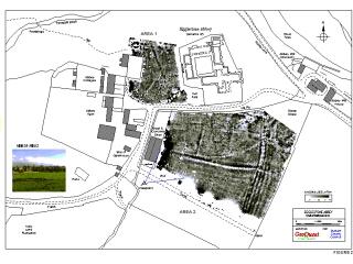
The results of geophysical survey are often very impressive, producing computer plots of recognisable structures
that seem to reveal a complete picture of the archaeology before any excavation has taken place. Sometimes people
question the need for any further investigation once they have seen geophysical survey results. However, geophysics
is not 'magic' and has its limitations just like any other technique. All geophysics can do is to measure certain
types of physical property in the soil, such as magnetism or electrical resistance. These properties can also be
affected by non-archaeological factors. There are many kinds of archaeological evidence that are not well-suited
to geophysical investigation because they do not produce the types of physical property which are easily detectable
by geophysical methods. Equally importantly, geophysical results need careful and unhurried interpretation. Some
knowledge of the background science, and experience of looking at geophysical plots, is essential so the results
are not 'over-interpreted' and misunderstood.
Learn more:
- A. Clark 'Seeing Beneath the Soil' (Batsford, London, 1990).
- http://www.brad.ac.uk/acad/archsci
Learn more about Magnetometry, Resistivity,
Ground Penetrating Radar, or return to Pre-Ex.
|
|