| |
|
|
Illustration
The purpose of illustration is to record the things we find, whether they are layers on an excavation, artefacts or
structures, so that written descriptions make more sense and the information is preserved for the future.
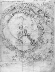
Illustration in archaeology used to mean one of two things: measured drawings (plans and sections) or photographs.
However, computers have now allowed us to record archaeology visually in many different and informative ways.
The purpose of illustration is to record the things we find, whether they are layers on an excavation, artefacts
or structures, so that written descriptions make more sense and the information is preserved for the future.
Artefacts can be photographed and studied at length afterwards, so these are not usually illustrated on site.
However, the layers, features and structures uncovered during an excavation may only be visible for a short time
while the excavation is happening, and it is vital to make an accurate and permanent illustrative record of them.
Every context must be included in a plan or section and photographed - however insignificant. It may turn out to
be much more important than it at first seemed, once post-excavation analysis has been carried out.
Why is it necessary to take the time and effort to draw features by hand, when modern cameras produce such clear
photographs? The answer is that photos are perspective images. Objects in the centre and foreground appear at a
different scale to those at the sides and in the background, so it is impossible to accurately measure the dimensions
of a feature from photographs alone. Measured drawings solve this problem.
Computers have introduced digital photography and mapping which can be linked to databases and GIS programmes.
Three dimensional (or 3D) reconstructions of features and structures are now commonplace. Computer graphics and
video technology allow a site to be reconstructed in virtual reality (or VR): it is now possible to take a VR
walk around the inside a long-vanished building (such as a Roman villa), admiring the decoration and lay-out of
the interior, or to travel across a VR landscape amongst Prehistoric barrows, henges and standing stones - when all
these details are accurate representations of excavated evidence. In turn, VR reconstructions, like conventional
artistic reconstructions by pencil and paint, are an aid to the imagination and help us to achieve a more
satisfactory interpretation of the archaeology.
Learn more about Plans, Sections, or return to
Recording.
|
|