| |
|
|
Topo Techniques
There are high-tech and low-tech ways to measure the ground surface and to record earthworks and structures.
The choice of method will be based on the size and complexity of the area to be investigated and the available
equipment.
The simplest method is to use three tape measures to create a grid using the 3,4,5 method. Measuring a position
from a grid using this method is called 'off-setting'. Based on simple geometry, a right angle can be created by
making the tapes work together as a triangle with sides of exactly 3, 4 and 5 metres. When the long side
(the hypotenuse) is 5 (or a multiple of 5 - as in Pythagoras' theorem), 3 and 4 (or their multiples) should
therefore meet at a right angle. Vertical heights, such as slopes, can be measured using tapes and measuring
rods in a step-like fashion.
A slightly more advanced method is to use a plane-table. This is a flat drawing board set on a tripod exactly over
a known point, to which a measuring tape is attached and extended by one surveyor to each of the points that are to
be recorded. A simple instrument like a ruler with a rifle-sight on top, called an 'alidaide', allows the operator
to sight along the tape to a vertical measuring rod at the recording point, and to record this measurement on a
plan. Occasionally, a 'self-reducing alidaide' is used, which can provide vertical as well as horizontal
measurements.
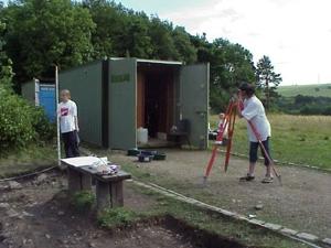
A more advanced optical method is to use a theodolite. This is basically a small telescope set on a frame that
allows it to rotate freely in both a horizontal and vertical direction. It is aimed at the point to be surveyed and
the horizontal and vertical angles are simply read off protractor scales on the side of the frame. A surveyors
chain (essentially a very accurate measuring tape) can be used to measure the distance.
Today most archaeologists' use electronic surveying methods. Total stations are a combination of theodolite and
an electronic 'tape' that can survey large areas quickly and accurately. For extremely large-scale surveys, or
surveys in areas of poor visibility, such as woodland, or few fixed features (such as open moorland) a GPS
(sometimes used in conjunction with a total station) is ideal.
Learn more:
- M. Bowden , Unravelling the Landscape, Tempus, Stroud, 1999.
Learn more about GPS, Total Station,or return to Pre-Ex.
|
|