| |
|
|
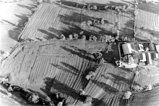
Ridge and Furrow
At Thrislington, one of the most obvious types of earthwork seen by the archaeologists was ridge and furrow. These
earthworks can be seen all over certain parts of the country in grassy fields. They give a 'corrugated'
appearance to the ground surface.
Medieval farmers did not deliberately arrange the soil into ridges and furrows. Large open fields surrounding a
village were divided up into strips, each owned separately. Some farmers owned a few strips, others owned more.
The farmer started in the middle of a strip at one end and ploughed up and down in a kind of long thin rectangular
spiral, until the entire strip was ploughed. The plough sliced through the soil and turned it over to one side,
just like a modern plough. Each time the farmer ploughed his strip, he would repeat this process, turning each
slice of soil towards the centre of his strip. The effect of this, over many years, was to pile up the soil towards
the centre of the strips. The furrows mark the dividing line between two strips.
NB for 'strip farming' document: The entire field would grow the same crop each year. To preserve the fertility of
the soil, each field would be used for cereals, peas or left fallow one year at a time.
Return to Earthworks.
|
|