| |
|
|
Earthworks
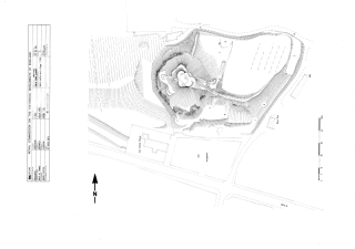
Earthworks are rises or falls in the ground surface that result from past human activity. For example, they can be
ditches, moats, banks, mounds, former roads and paths, and ponds; they can be preserved in, or close to, their
original state, or they could have been modified and re-shaped by collapse, later activity and centuries of slow
erosion.
Archaeologists often divide earthworks into positive and negative types: positive being those which are built up of
archaeological material, such as banks or mounds; negative being those which are cut into the surrounding earth - a
good example of negative earthworks are the deep channels left by many years of human and animal traffic along
roadways in medieval settlements - these are known as 'hollow ways'.
Most monuments and sites, such as prehistoric burial mounds or deserted medieval villages, are a composite of
negative and positive earthworks. Archaeologists can map and record earthworks using aerial photography and
topographical survey. Whereas most people would be able to identify a simple round barrow or the bank and ditch
defences of an Iron Age hillfort, complex earthworks are often confusing to view at ground level alone.
A mass of 'humps and bumps' can seem to lack form and pattern, especially when they represent a number of different
periods of activity, and are possibly not in a good state of preservation. However, by systematic measurement and
recording, it is almost always possible to 'make sense' of these features. Accurate maps of earthworks can be used
to reconstruct the plans of villages and field systems, and help archaeologists decide where to excavate for more
information.
Earthworks in ploughed fields are sometimes so degraded that they are hard to see, but can be recorded with careful
painstaking work. At some sites, earthworks surround surviving buildings, such as a church or farmhouse that may be
all that remains of a former village. Earthworks sometimes cover many miles of countryside, revealing whole
landscapes of ancient fields, trackways and settlements.
Learn more about Ridge and Furrow, or return to Topo Survey.
|
|