Non Gamstop Casinos
Non Gamstop Sports Betting Sites
Non Gamstop Casinos
Non Gamstop UK Betting Sites
Non Gamstop Casinos
HOME
SITES
ARCHAEOLOGY
HELP
CREDITS
RECONSTRUCTIONS
VRML MODELS
ARCHIVE
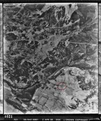
Forcegarth Pastures: Aerial View
This is a vertical aerial photograph of the Forcegarth Pasture settlements.
Forcegarth North is marked by a red circle.
Learn more about
aerial photographs
or see
more aerial photographs of Forcegarth
.
More great reads
Non Gamstop Casinos
Non Gamstop Casinos
Casinos Not On Gamstop
Best Non Gamstop Casinos
Non Gamstop Casinos
Gambling Sites Not On Gamstop
UK Casino Not On Gamstop
Non Gamstop Casino Sites UK
Non Gamstop Casinos
Non Gamstop Casinos UK
Casinos Not On Gamstop
Casinos Not On Gamstop
Casinos Not On Gamstop
Casinos Not On Gamstop
Non Gamstop Casinos UK
UK Casino Sites Not On Gamstop
Sites Not On Gamstop
Sites Not On Gamstop
Non Gamstop Casino Sites UK
Casinos Not On Gamstop
Casinos Not On Gamstop
Slots Not On Gamstop