| |
|
|
Topo Survey
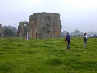
Many sites are visible on the ground as a series of 'humps and bumps'. These earthworks can be very confusing to
look at from ground level. An accurate plan of them can reveal the outlines of building foundations, field patterns
or other such features that had not previously been recognised. This plan is produced by topographical ('shape of
the ground') survey.
Measured topographical survey for military purposes began in the late 18th and 19th centuries when the Ordnance
Survey (OS) was set up. The early techniques were turned to archaeological use by pioneer archaeologists with a
military background such as General Pitt Rivers. In the early 20th century, many of Britain's ancient monuments
were accurately mapped for the first time by archaeological surveyors such as O. G. S. Crawford, the official
Ordnance Survey archaeologist.
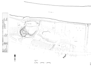
Every site is given its own regular internal system of co-ordinates known as the site grid. The position of any
point on the ground surface can be calculated by measuring (or 'triangulating') from known points on this grid,
using trigonometry. The distance and angle to these new points must be measured both vertically and horizontally
(and the latter in both a north-south and an east-west direction). Mathematics can then be used to calculate their
grid co-ordinates. In the past, this was done manually. Only very experienced surveyors could work quickly and
accurately. Thankfully, computer technology has made surveying a lot less arduous. Archaeologists today normally
use electronic surveying instruments such as GPS or Total Stations. The measured points (which often number many
hundreds or thousands) are downloaded into a computer programme and used to produce a digital plot.
It is essential to locate the site grid in relation to the Ordnance Survey national grid system, otherwise future
researchers will be unable to compare their findings with yours. This is done by measuring off fixed features in
the surrounding area such as buildings, field boundaries or OS 'trig points'. Since these are shown on large-scale
OS maps, they allow the site grid to be overlaid onto such a plan. If suitable points are not available, a GPS can
be used to locate the site grid corners.
Learn more:
- M. Bowden, Unravelling the Landscape, Tempus, Stroud, 1999.
Learn more about Earthworks, Topo Techniques, or
return to Pre-Ex.
|
|