HOME     SITES     ARCHAEOLOGY     HELP     CREDITS    

RECONSTRUCTIONS VRML MODELS ARCHIVE
PAST PERFECT LOGO
 
Aerial view of Forcegarth Pastures
 
ENLARGE IMAGE
 

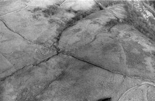
Forcegarth Pastures: Aerial View

This is an oblique aerial photograph of the Forcegarth Pasture North settlement. You can see the enclosure wall and the houses inside the enclosure.

Learn more about aerial photographs or see more aerial photographs of Forcegarth.
 
PREHISTORIC BURIALROMAN PERIOD FARMANGLO-SAXON ROYAL PALACEMEDIEVAL VILLAGEMEDIEVAL CASTLEPOST-MEDIEVAL LEAD WORKINGTWENTIETH CENTURY COAL MINE